With high pressure over the UK bringing continued settled conditions, temperatures will continue to increase through the end of the week and into the weekend.
Friday will be another warm day, with highs of 32°C possible in central England. High cloud will move into the southwest of England. Some isolated showers and thunderstorms could move into western parts of the UK, and develop elsewhere in northern Scotland and northeast England by the afternoon. Further isolated thunderstorms will move into the far southwest overnight.
Deputy Chief Meteorologist, Dan Holley, said: “The highest temperatures from this hot spell are forecast for Saturday, with low 30s Celsius fairly widely across England, and up to 34°C possible in eastern areas. Despite this, the more uncomfortable heat will be in northern and western areas initially, where despite somewhat lower temperatures the air will be more humid.
“While Saturday will be a dry and fine day for many, a few showers or thunderstorms will be possible across northern and western parts of the UK, with an increasing risk of some intense thunderstorms developing across portions of north Wales, northern England and southern Scotland later in the afternoon and into the evening hours, which could bring heavy downpours, frequent lightning, gusty winds and possibly large hail.”
A Yellow Severe Weather warning for Thunderstorms has been issued for the Midlands, northern England and parts of north Wales. Whilst many places will likely remain dry and unaffected, scattered thunderstorms may develop during Saturday afternoon, lasting through the evening hours, moving northeastwards before eventually clearing to the North Sea by the early hours of Sunday. The most intense thunderstorms could produce frequent lightning, large hail and gusty winds, along with some heavy downpours for a time. This may lead to some surface water impacts in places.
⚠️ Yellow weather warning issued ⚠️
Thunderstorms across parts of northern England and Wales
Saturday 1500 – Sunday 0400
Latest info 👉 https://t.co/QwDLMfRBfs
Stay #WeatherAware⚠️ pic.twitter.com/5jeHHHG7Ee
— Met Office (@metoffice) June 20, 2025
Dan continued: “The nights will also be quite warm, with the possibility of temperatures not falling below 20°C in some areas, making it hard to sleep. This is what we term a ‘tropical night’.
“Temperatures will ease from the west on Sunday as fresher air arrives from the Atlantic, although parts of East Anglia and the far southeast of England could still see 28-29°C for a time.”
Many of us will wake to a warm and humid start on Friday, with temperatures soon rising beneath sunny skies across the country ☀️
Cloudier towards the west, with a few light showers spreading across Wales and South West England through the morning 🌦️ pic.twitter.com/nUfLOM4h44
— Met Office (@metoffice) June 19, 2025
UKHSA Heat Health Alert
The UK Health Security Agency (UKHSA) has issued an Amber Heat Health Alert for the whole of England. This is aimed at the health and social care sector, the responder community, the voluntary and community sector and government departments when adverse temperatures are likely to impact on the health and wellbeing of the population.
Dr Agostinho Sousa, Head of Extreme Events and Health Protection at UKHSA, said: “We have already seen warm weather across the week, and temperatures are set to increase in the coming days, exceeding 30°C in many areas.
“Our findings show that heat can result in serious health outcomes across the population, especially for older adults or those with pre-existing health conditions. It is therefore important to check on friends, family and neighbours who are more vulnerable and to take sensible precautions while enjoying the sun.
“The forecasted high temperatures may also lead to an increasing demand for remote health care services and an impact on the ability of services delivered due to heat effects on the work force.’’
Where is the heat coming from?
Interestingly the cause of the high temperatures this week is not as a result of hot air moving north from Iberia or northwest Africa like we often see. Instead, it is air that has originated over the North Atlantic south of Greenland but in a layer between 2-4 km above the ground.
As the air approaches the UK, it descends within the area of high pressure. Descending air rapidly warms – at around 10°C per kilometre. As we head into the weekend, high pressure begins to move away from the UK towards the east, drawing up air that has been heated over several days over the near continent. This allows temperatures to rise into the low 30s Celsius.
Chief Meteorologist Matthew Lenhert joined our Presenter Alex Burkill on this week’s Deep Dive on YouTube to explain more, see the video below.
Not just heat to be mindful of
As well as increasing temperatures, high pollen levels will bring challenges for hay fever sufferers and UV levels will also be high. We have advice on our website on how to reduce the impacts from high pollen levels and preventing sunburn, enjoying the sun safely.
Our pets can also need a little more care during hot spells. British Veterinary Association President Dr. Elizabeth Mullineaux said: “Each summer, vets see pets suffering from heat-related problems and illnesses, such as heatstroke, breathing problems, burnt paw pads and sunburn, some of which can sadly be fatal.
“With high temperatures this week, make sure your animals have access to fresh drinking water, good ventilation and shade from direct sunlight at all times. When it comes to walking or exercising dogs, don’t take them out during the heat of the day- stick to early morning or late evening walks- and never leave them inside a car, caravan or conservatory even for a little while. If you’re concerned about your pet’s health, contact a vet as quickly as possible.”
Chances of extreme heat in the UK increasing due to climate change
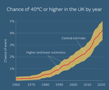
Yesterday Met Office scientists published a new study detailing the increasing likelihood of extreme temperatures in the UK, revealing that the chance of exceeding 40°C in the UK is accelerating at pace.
The scientists found the chance of exceeding 40°C has been rapidly increasing, and it is now over 20 times more likely than it was in the 1960s. They estimate a 50-50 chance of seeing a 40°C day again in the next 12 years and also found that temperatures several degrees higher than we saw in July 2022 are possible in today’s climate.
Further ahead
Temperatures are forecast to drop on Sunday, though the far east of England could hold on temperatures up to 28°C through Sunday. Elsewhere, westerly mobility will move in bringing fresher air, cloud and outbreaks of rain. These conditions are expected to continue through next week, with spells of brighter and drier weather too.
Alex Deakin looks at what the weather has in store a little further ahead in our latest 10 Day Trend which you can watch below.


